Baja

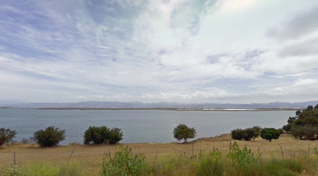
The soft hills around Ensenada can be seen across All Saints Bay from BC-23, a short road connecting the town of Maneadero to the cape of Banda and the Estero Beach sand bar. Ensenada is the largest municipality of Mexico; besides most of the state of Baja California it also administers the sparsely populated Guadalupe Island, the westernmost point of Latin America.

Las suaves colinas cerca de Ensenada se asoman tras la Bahía de Todos los Santos mientras recorremos la BC-23, una corta carretera que une el pueblo de Maneadero con el cabo de Banda y con el banco de arena de la Playa del Estero. Ensenada es el municipio más extenso de México; junto a la mayor parte del estado de Baja California, incluye también la escasamente poblada Isla Guadalupe, el punto más occidental de América Latina.

https://goo.gl/maps/Z1bawZyHU3m

Facebooktwittergoogle_plusredditpinterestFacebooktwittergoogle_plusredditpinterest

Kasiks

A train bridge passes over the Kasiks River just as it joins the Skeena River, as viewed from the Yellowhead Highway. The highway, which joins four Canadian provinces, runs next to the Skeena for a long and scenic stretch in British Columbia.

(Bonus tip: the Google Street View meeple is an eskimo!)

Un puente ferroviario pasa sobre el río Kasiks en su confluencia con el río Skeena, visto desde la Yellowhead Highway. La autopista, que une cuatro provincias canadienses, discurre junto al Skeena en este largo y pintoresco tramo a través de la Columbia Británica.

(Bonus tip: ¡el muñequito de Google Street View es un esquimal!)

https://goo.gl/maps/wU5Ac

Facebooktwittergoogle_plusredditpinterestFacebooktwittergoogle_plusredditpinterest

Malibamat’so

A bridge on the reservoir of the Malibamat’so River near the town of Ha Lejone in Lesotho. The reservoir, a widened version of the river path, is created by the second largest dam in Africa, which is also the one placed at a higher elevation.

Puente sobre el embalse del río Malibamat’so cerca de Ha Lejone, en Lesotho. El embalse, una versión ensanchada del recorrido del río, se debe a la segunda presa más grande de África, que es también la situada a mayor altura sobre el nivel del mar.

https://goo.gl/maps/7jGNX

Facebooktwittergoogle_plusredditpinterestFacebooktwittergoogle_plusredditpinterest

Saatse

Perennious trees line the road across the Saatse Boot area of Russia, linking the Estonian villages of Lutepää and Sesniki. The 900 m stretch of Russian road is noteworthy in that, up until recently, it was the only way to reach a number of Estonian towns – making them into virtual exclaves, impossible to reach from the rest of Estonia without traveling through Russian territory.

Árboles de hoja perenne rodean la carretera que comunica las aldeas estonias de Lutepää y Sesniki atravesando el área rusa conocida como la Bota de Saatse. La particularidad del tramo ruso de carretera, de apenas 900 m, es que hasta hace bien poco era la única vía de comunicación hacia varias poblaciones estonias; éstas eran exclaves virtuales, imposibles de alcanzar desde el resto de Estonia sin pisar territorio ruso.

https://goo.gl/maps/tCPMP

Facebooktwittergoogle_plusredditpinterestFacebooktwittergoogle_plusredditpinterest

Uksichan

A view of the waters of the Uksichan river at Esso, a town in Kamchatka, as they merge with the Bystraya River. A popular destination for rafting, the Bystraya river traces a winding route through the volcanic landscape of the Russian peninsula and eventually meets the eponymous Kamchatka River.

Vista de las aguas del río Uksichan a su paso por la población de Esso, en Kamchatka, justo antes de confluir con el río Bystraya. Este río, popular entre los entusiastas del rafting, serpentea por el volcánico paisaje de la península rusa hasta acabar por encontrarse con el epónimo río Kamchatka.

https://goo.gl/maps/AaeMi

Facebooktwittergoogle_plusredditpinterestFacebooktwittergoogle_plusredditpinterest

Atol das Rocas

A rarity in the South Atlantic Ocean, the Atol das Rocas (Rocks Atoll) is a Brazilian nature reserve and World Heritage site. Remote and free of human presence, the atoll is home to numerous turtles, sharks, dolphins and birds who enjoy its character as a wildlife sanctuary.

Una rareza en el Atlántico Sur, el Atolón de las Rocas es una reserva natural brasileña reconocida como Patrimonio de la Humanidad. Remota y deshabitada, el atolón cobija a numerosas tortugas, tiburones, delfines y aves, que disfrutan de su carácter de santuario para la fauna.

https://goo.gl/maps/EYlER

Facebooktwittergoogle_plusredditpinterestFacebooktwittergoogle_plusredditpinterest

The caves of Khamar

In the heart of the Mongolian Gobi desert, and just a few miles to the north of the symbolic Khamar Monastery (which is also available in Street View), a crumbling collection of caves and walls greets the visitor. Those were used by monks in 108-day long meditation retreats.

En el corazón del desierto mongol del Gobi, apenas unos kilómetros al norte del simbólico monasterio de Khamar (también disponible en Google Street View), una ruinosa colección de cuevas y muros saluda al visitante. Aquí solían mudarse los monjes durante unos retiros de meditación que duraban 108 días.

https://goo.gl/maps/g79hw

Facebooktwittergoogle_plusredditpinterestFacebooktwittergoogle_plusredditpinterest

Colter Bay

Named after the Teton Range (which, in turn, is named after the French word for breast, due to the appearance of its three tallest mountains), the Grand Teton National Park, just 10 miles south of the famous Yellowstone National Park, offers over 200 miles of trails and plenty of wildlife spotting oportunities to the avid trekker.

Llamado así por la cordillera Teton (que, a su vez, toma el nombre de la palabra francesa para pecho, debido a la apariencia de sus tres picos más altos), el Parque Nacional Grand Teton, apenas 15 km al sur del afamado Parque Nacional de Yellowstone, ofrece a los entusiastas del senderismo más de 300 km de caminos y multitud de oportunidades para observar la fauna.

https://goo.gl/maps/Nq0Wg

Facebooktwittergoogle_plusredditpinterestFacebooktwittergoogle_plusredditpinterest